|
________________
CM . . . .
Volume V Number 19 . . . . May 21, 1999
The ambit of the atlas extends from prehistoric (Norse) times to
the 1960's and is organized in three broad sections: (i) "National
Perspectives", which examines issues from the perspective of the
country as a whole: exploration, boundaries, settlement,
transportation, resources, agriculture, environment, etc.; (ii)
"Defining Episodes", which illustrate turning points in the
nation's history: wars, immigration, etc.; and (iii) "Regional
Patterns", which, as the name suggests, examine events and
circumstances of particular significance to one part of the
country. Each of these is prefaced by a very useful introduction
which puts the collection of individual studies into context.
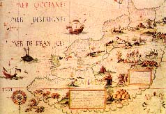
The maps, themselves, are an combination of award-winning hand-drawn and
computer-generated pieces of cartographical art. The accompanying charts
and graphs are presented in a wide variety of forms and provide an
excellent and engrossing laboratory for the general reader in learning to
deal with the interpretation of graphical presentations. The clear
presentation and written explanations make the atlas easily accessible to
the general reader. At the senior school level (and, with appropriate
guidance, below that), it could be used with great effect in individual
research projects and classroom discussion and interpretation. For most
purposes, the amount of information provided would suffice, but the
opportunity is there for students to return to the original volumes for
yet further detail if that is desired.
In summary, this is an invaluable addition to the senior school and
postsecondary teaching and study repertoire.
Highly Recommended.
Alexander D. Gregor is the Director of the Centre for Higher
Education at the University of Manitoba.
To comment on this title or this review, send mail to cm@umanitoba.ca.
Copyright © the Manitoba Library Association.
Reproduction for personal use is permitted only if this copyright notice
is maintained. Any other reproduction is prohibited without
permission.
Published by
TABLE OF CONTENTS FOR THIS ISSUE - MAY 21,
1999.
AUTHORS |
TITLES |
MEDIA REVIEWS |
PROFILES |
BACK ISSUES |
SEARCH |
CMARCHIVE |
HOME
|

 The Concise Historical Atlas of Canada is a one volume
condensation of a three-volume series published in 1987, 1990 and
1993.The original series was the first of its kind and proved to be
a national best seller - a status obviously awaiting this sequel.
The volume was prepared by a committee of geographers, and, in this
case, a committee proved be the proper vehicle for ensuring balance
and to comprehensiveness. The atlas comprises 67 plates from the
original series, along with a myriad of graphs and illustrations to
expand upon the information presented in cartographical form. Each
of the plates is dedicated to a single subject or theme, with
supporting bibliographical information provided at the back of the
book.
The Concise Historical Atlas of Canada is a one volume
condensation of a three-volume series published in 1987, 1990 and
1993.The original series was the first of its kind and proved to be
a national best seller - a status obviously awaiting this sequel.
The volume was prepared by a committee of geographers, and, in this
case, a committee proved be the proper vehicle for ensuring balance
and to comprehensiveness. The atlas comprises 67 plates from the
original series, along with a myriad of graphs and illustrations to
expand upon the information presented in cartographical form. Each
of the plates is dedicated to a single subject or theme, with
supporting bibliographical information provided at the back of the
book.